
 Log in








Confirm the building. Measure the roof.

On the Permit & Compliance plan, $149 a month. Put the whole crew on it. Nobody pays per person.
A measured result has to earn the label.
Each step leaves its evidence on the job record.
- Step 1
Confirm the right building
Use the job address as a starting point, then confirm the roof scope before analysis begins.
- Step 2
Keep the calibrated capture
Keep the image, where it came from, when it was taken, and the scope you confirmed, together on the job.
- Step 3
Measure from the best public evidence
Qualified public LiDAR (USGS 3DEP and NOAA Digital Coast) measures the roof in 3D. Where LiDAR cannot, Google Solar supplies measured pitch and area with clearly labeled derived linework.
- Step 4
Review the result, its source, and its gaps
Four things stay apart. What we measured. What we called an estimate. What we could not get. And what you still check in the field.
- Step 5
Read the roof off the plan sheet
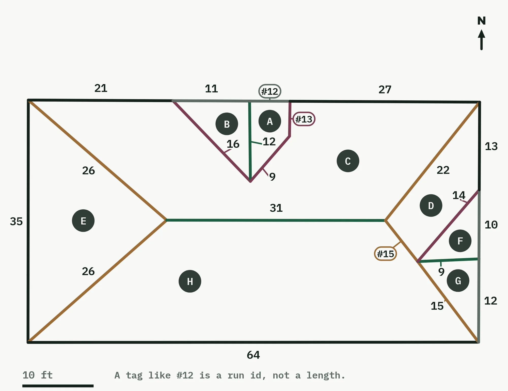
The plan draws the measured roof and keeps it clean. A run with room gets a plain number. A run without room gets a hollow tag, like #12. Every facet gets a letter, and it is the same letter on the photo, on the plan and in the schedule. North arrow, scale bar, and the key set on the drawing itself, so the tag's meaning travels with the sheet. The marked photo beside it carries the same runs and the same facet letters - no lengths, no pitch text, no fill - so the picture stays a picture of the roof.



Already paying for roof reports? Bring them here.
A contractor who already buys roof reports should not have to buy the numbers twice to get them onto a job.
The replacement math
A vendor who measures roofs bills you for every report, one by one. Here the takeoffs ride the plan: Operator includes 15 measured reports a month, Growth includes 30. Measure 30 roofs in a storm month and at our own overage rate that work prices out at $270 - and on Growth it is simply in the plan, with more reports at $9 each after that ($12 on Operator). No per-roof invoice from a report vendor, and the measurement lands on the job it belongs to.
Start from the address. Keep the evidence attached.
Open the job, confirm the intended building, and review the available measurement path.
Availability depends on the saved scope, feature access, quota, service state, and qualifying public LiDAR coverage.